Equinox
Noon Sun
 Yesterday was the Spring Equinox (2014). My friend and I
brought
the sextant to a nearby beach to shoot the noon sun.[1] A
passing beach-walker called out to us saying, “That looks like hard
work—GPS
would be easier.” In an age when our cell phones know which end of the
park bench we are sitting on, why bother to shoot the sun? That is
perhaps difficult to explain.
Yesterday was the Spring Equinox (2014). My friend and I
brought
the sextant to a nearby beach to shoot the noon sun.[1] A
passing beach-walker called out to us saying, “That looks like hard
work—GPS
would be easier.” In an age when our cell phones know which end of the
park bench we are sitting on, why bother to shoot the sun? That is
perhaps difficult to explain.
There is just
something appealing
about deducing one’s latitude simply and directly, merely by observing
the
height of the sun at or near the time it crosses the celestial equator.
No complicated math is needed—no
calculators or tables. The calculation is as simple as
subtracting the sun’s observed height from 90°.
In centuries past mariners depended upon
the
noon sun for latitude. An accurate timepiece was not
needed because only the sun’s height matters for
the noon latitude, not
the time at
which it reaches maximum height. It is necessary, however, to
correct for the sun’s declination (angular distance north or south of
the celestial equator).
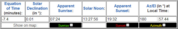
The March 20, 2014 equinox occurred at
4:57 PM universal time (AKA Greenwich mean time), which corresponds to
a
few minutes before
1:00 PM EDT, where I
live in Charleston, South Carolina.
At the time of the
equinox the sun’s
declination is zero (by definition).
Charleston lies about 5°
west of the 75° meridian.
Solar noon
yesterday, the
time that the sun reached its maximum height, was about a half hour
after the equinox. By then the sun was less than a minute
north of the equator. The exact time of solar noon for any
location, as well as other interesting times, may be calculated at this NOAA
page, from
which the following table is reproduced.
Because solar noon occurred at nearly
the
same time as the equinox, declination
can be ignored when computing latitude from
yesterday’s noon sun. The
simplicity of this situation is summarized in the sketch below.
The above diagram should be
self-explanatory. As we learned in school, earth’s
equator is 90° from the
pole—the same holds for
the celestial poles and equator.
Similarly the horizon
is 90° from the observer’s
zenith, an imaginary point directly overhead in the sky.
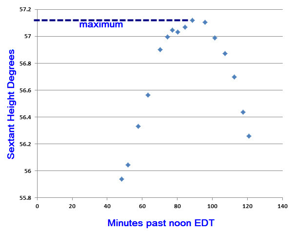
When shooting sights yesterday,
we did not know (or
pretended not to know)
exactly when the sun would reach its maximum height. We began taking
sights at about ten minutes before 1 PM EDT and shot the last sight at
about five past two. This allowed us to plot a curve as the
sun rose to its maximum height and then began to descend. In
the following graph, the horizontal axis is time in minutes past noon
EDT and the vertical axis is sextant height (Hs) in degrees.
(Sextant height is uncorrected.)
 To compute observed height Ho from sextant height Hs, it is necessary
to enter a few corrections. The largest correction is half the
diameter of the sun. The reason it is necessary to make this
particular correction is that we measure the height of the sun’s
lower limb (i.e., the point at which the lower limb appears to touch
the horizon in the sextant view), while astronomical data, such as the
time of the equinox, refer to the center of the sun. Rather than
correct each individual observation, we corrected only the maximum
sextant height, since that was the only point required for computing
latitude.
To compute observed height Ho from sextant height Hs, it is necessary
to enter a few corrections. The largest correction is half the
diameter of the sun. The reason it is necessary to make this
particular correction is that we measure the height of the sun’s
lower limb (i.e., the point at which the lower limb appears to touch
the horizon in the sextant view), while astronomical data, such as the
time of the equinox, refer to the center of the sun. Rather than
correct each individual observation, we corrected only the maximum
sextant height, since that was the only point required for computing
latitude.
The DIP correction refers to the height
of the observer’s
eye. The formula is 1.76 multiplied by the squareroot
of height in meters. Lastly, the sextant zero point
(where the reflected horizon makes a continuous line with the actual
horizon) is a fraction of a minute below the zero mark on the scale.
This brings us to the moment of truth,
so-to-speak. Subtracting 57°
22’ from 90° gives a
latitude of 32° 38’.
Our actual latitude by the park bench method[2]
was 32°
35.5’. Therefore we missed our latitude by 2.5’
(two and a half nautical miles). This degree of accuracy might be
acceptable at sea, but seems rather unsatisfactory for observations
from the beach, which is a perfectly stable platform.
We did
not enter all corrections, however, I think the most likely explanation
for the
discrepancy is inaccuracy of the observations themselves. The
horizon was hazy
and the sun partly obscured by sporadic wispy clouds.
Most of all, the navigator was inexperienced in the art of
swinging the sextant—a skill that may be likened to bowing the violin.
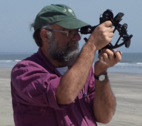
[1]
In the photo my friend Chris is taking a practice sight at Kiawah
Island beach.
[2] GPS, of
course.